Braunstone |
![[Search]](../../../images/buttons/search.gif) |
|
|
|
||
|
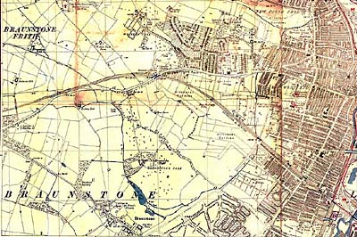
A map from the 1930s shows Leicester to the right, South Braunstone (bottom centre right), Braunstone Village (bottom centre left), and the land on which North Braunstone was to be built (centre). This map is courtesy of Wartime Leicestershire, where a larger version can be seen. |
|
Housing
|
Home>>Community>>Resources>>Braunstone>>Map
![[Hosted by the University of Leicester]](http://www.le.ac.uk/corporateid/navigation/hostedby.gif) ![[University Home]](http://www.le.ac.uk/corporateid/navigation/unihome.gif)
![[East Midland Oral History Archive Home Page]](http://www.le.ac.uk/corporateid/navigation/archive.gif)
![[contact the East Midland Oral History Project]](http://www.le.ac.uk/corporateid/navigation/contact.gif) |
|
|
|