Lithospheric structure of West Greenland
Richard England
in conjunction with colleagues at the Geological Survey of Greenland, University of Durham, University of Leeds and University of Bristol.

A question that is key to our understanding of the evolution of the Earth as a planet is how the continental crust and underlying subcontinental mantle lithosphere stabilises and evolves over time. In particular, comparatively little is known about the structure and physical properties of the subcontinental mantle lithosphere. By coupling seismology with geochemistry it is possible to compare the present structure, obtained from seismology, to the structure at intervals in the past, obtained from petrological and geochemical studies of xenolith suites. Recent advances in all these fields mean that it is possible to resolve details with increasing accuracy and precision.
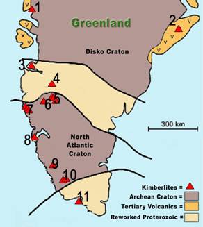
West Greenland provides an ideal natural laboratory to study the evolution of some of the Earth’s oldest lithosphere. Its crustal structure and evolution has been well studied and shown to comprise Archean and Proterozoic terrains separated by approximately E-W trending boundaries. These terranes have then suffered E-W directed Mesozoic extension resulting in the formation of the Labrador sea. Recent seismic work has produced the first 3-D tomographic models for the crust and upper mantle which suggest a seismically thin crust and mantle root, compared with other well studied cratonic regions (e.g. the Kaapvaal craton). Because of its great age, the region has been the focus of petrological, geochemical and isotopic studies since the 1960’s. What is now exciting interest is the recent discovery in West Greenland of extensive suites of mantle derived xenoliths within Kimberlite pipes which erupted between 600 and 55 Ma. Extensive and detailed study of these kimberlites and xenoliths ongoing at the University of Durham can be used to obtain estimates of the thermal gradient, composition and seismic anisotropy of the lithosphere at the time of eruption. These results can be compared with the present information from seismic studies and used to describe the evolution of the lithosphere over time.
To study the lithospheric structure of west Greenland 5 SEIS-UK instruments have been deployed along a profile running orthogonal to the boundary between the Archean North Atlantic Craton and the Nagssugtogidian Proterozoic mobile belt and as close as possible to the sites of xenolith occurrences (see map above provided by Graham Pearson, University of Durham). This will enable us to resolve differences in the structures of the adjacent terranes than has been possible with existing seismic networks and make direct comparisons of present day mantle structure with the petrological data from the suites of xenoliths.
Back to my research page